Minds on Maria

Sunday morning update from Hyde County:
Local officials may reach a decision regarding emergency protective measures this evening. The Hyde County Emergency Services Department will continue to monitor the forecast for Hurricane Maria and issue advisories as appropriate.
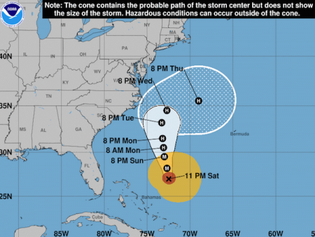
Has this been the longest hurricane season, or what? Ocracoke has been lucky (so far) and missed all the serious stormy weather, while we watch and worry about others in Texas, Puerto Rico, and the Caribbean. But Harvey, Irma, Jose, and now Maria have all, at one time or another, looked like they could head our way, and I have to admit, it's wearying to be steadily in and out of the cone of uncertainty. This happens every year – we spend a good part of the season simultaneously preparing for a possible hurricane while going about business as usual.
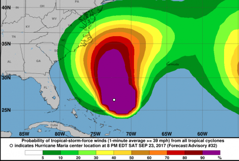
So here we are again. Maria could take a turn toward the Outer Banks. And it's a big storm, so we have, according to the National Hurricane Center, a 50-60% chance of tropical storm force winds. We will almost certainly have dangerous surf and rip currents. Be careful out there.
Maria reminds some local people of Matthew. Matthew was a mess for eastern NC, including Ocracoke, last October. Maria needs to turn out to sea prontosaurus.
Stay tuned. We will post what we learn from local officials.
From NPS early Sunday morning:
Ocracoke Campground to close at Noon today ahead of potential tropical storm conditions.
Due to predicted tropical storm conditions, the Ocracoke Campground will be temporarily closed starting at 12:00 pm today, Sunday, September 24, 2017. The campground will reopen post-storm after safety assessments are completed.Swimming is not advisable while there is a high risk of rip currents. For a daily rip current forecast go tohttp://www.weather.gov/beach/mhx. For information on rip currents safety go to:http://www.ripcurrents.noaa.gov.
Beach access ramps will remain open to off-road vehicles and pedestrians at this time, but some beach routes may become impassable. Daily beach access ramp status updates are available on the Seashore Facebook page athttp://facebook.com/capehatterasns.
For more weather-related information, check local NOAA weather forecasts, and local radio and media for updates and advisories.

Hyde County put out the following statement on their Facebook feed Saturday evening:
Local Emergency Protective Measures
Local officials began discussing emergency protective measures this evening. The Hyde County Emergency Services Department will continue to monitor the forecast for Hurricane Maria and issue advisories as appropriate.
Even though the most recent official NHC track may be more favorable for inland areas, everyone needs to review their household hurricane preparedness plans and begin implementing them. Direct impacts may be felt across our area within 72-114 hours. In addition, everyone needs to pay close attention to official sources of information and heed the directives issued by local officials. Please remember that households need be self-sufficient for at least 72 hours following an emergency.
The National Hurricane Center posted at 11pm:
1. Maria's forecast track continues to be northward, paralleling the U.S. east coast, and it is likely that some direct impacts will occur along portions of the coast next week. Interests along the coast of the Carolinas and the Mid-Atlantic should monitor the progress of Maria, as tropical storm or hurricane watches may be needed for part of this area on Sunday. 2. Swells from Maria are increasing along the coast of the southeastern United States and are expected to reach the Mid-Atlantic coast on Sunday. These swells will likely cause dangerous surf and rip currents at the beach through much of next week. For more information, please monitor information from your local National Weather Service office at www.weather.gov


