Hey, Sandy Girl, My My My My Baby

The report was issued from the NWS offices in Newport/Morehead City, NC.
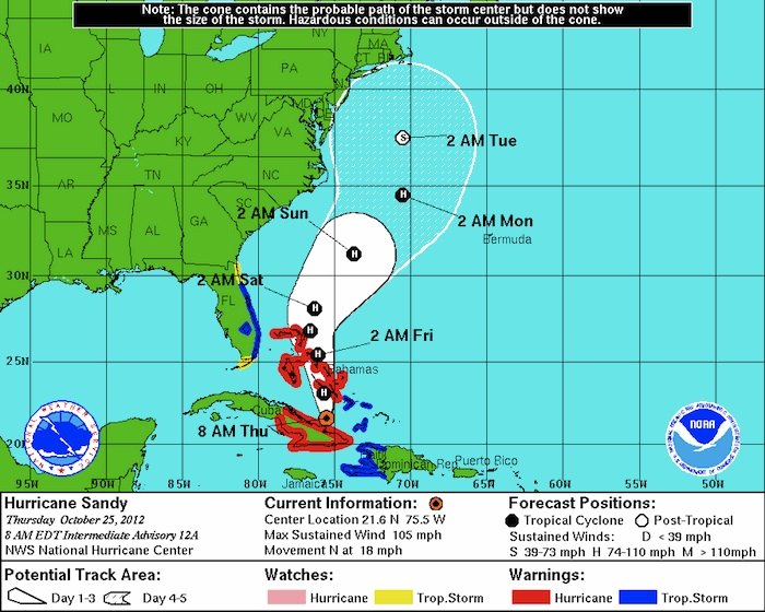
Hurricane Sandy will lift north of the Bahamas Friday then move northeast as a category 1 Hurricane well offshore of the Carolina coast. Sandy is forecast to gradually become post tropical off the Mid Atlantic coast later Monday. Models continue to differ on the exact track Sandy will take, however they all indicate it will be a large system that will be close enough to the North Carolina coast to produce strong winds.These winds will lead to very rough surf...dangerous rip currents...ocean over wash and moderate coastal flooding. Heavy rain may also occur, especially near the coast.
The main coastal flooding threat will be on the southern portion of the Pamlico Sound and the east facing beaches north of Cape Lookout late Saturday through Sunday evening. As the low lifts further north and winds become more northwest the flooding threat will shift to the sound side of the Outer Banks Sunday Night into Monday.
If the low tracks close to the coast very strong winds of 40 to 50 mph or greater will be likely, however winds would be more likely 30 to 40 mph if the system tracks further offshore.
Rainfall will also depend on the track with a more offshore solution leading to amounts of 1 to 3 inches and a closer track possibly leading to 5 or more inches.
For this information and more graphics, please check otu: http://www.erh.noaa.gov/mhx/downloads/briefings/LatestBriefing.pdf
Editor's note: Please let us know in the comments if you can Name That Tune from the headline. And if so, will it be stuck in your head all day?


